Styles / Digital & social
Drone top-down photography
- Key: the sun, about 45° to the camera’s left, high, hard.
Key high: about 30–45° above eye level, angled down.
Schematic, not to scale: worked out from the style’s choices. No set-up of this style has been rendered yet.
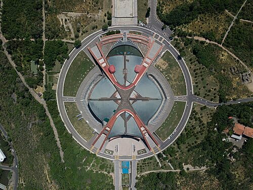
Karen Demirchyan Sports and Concerts Complex top down view from drone
Aleksey Chalabyan (Xelgen), Karen Demirchyan Sports and Concerts Complex top down view from drone, 28 May 2019. Wikimedia Commons; CC BY-SA 4.0. Source: Karen Demirchyan Sports and Concerts Complex top down view from drone at Wikimedia Commons, photographer's own-work upload

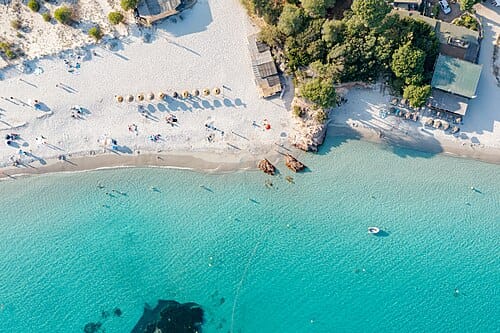
Top-down aerial of Palombaggia Beach, France
dronepicr, Top-down aerial of Palombaggia Beach, France, 8 July 2022. Flickr / Wikimedia Commons; CC BY 2.0, confirmed by Commons' Flickr licence review on 3 March 2023. Source: Top-down aerial of Palombaggia Beach, France at Wikimedia Commons, from dronepicr's Flickr photograph 52723809351

Look vertically down from a drone until fields, beaches, roofs and roads become a flat arrangement of lines and colour. Exclude the horizon, keep the ground sharp and use repetition, a shoreline or one small vehicle to organise the frame. Clean digital colour and occasional long cast shadows make an inhabited landscape read first as a graphic surface. This is the nadir, pattern-led strand of drone photography, not every aerial view.
Built mostly on one system: Deadpan document. What systems are.
Shoot sheet for your kit A prompt for an image model The photographs
How the look is made
- Point the camera straight down and exclude the horizon; make the ground, rather than the sky or a receding vista, fill the picture.
- Move the viewpoint until crop rows, roof outlines, paths or shorelines become a legible pattern of repeated lines and colour fields.
- Keep the ground sharp across the frame; let a small vehicle or other minor feature supply scale without turning it into a close portrait.
- Choose either dense all-over repetition or one small shape against open water, sand or land; do not rely on foreground-to-background layering.
- Use directional sun when cast shadows improve the geometry, or even daylight when surface colour matters more; preserve bright surfaces and keep the digital finish clean.
Shoot sheet for your kit
Fill in your camera, lenses and lights, and the sheet says which light plays each part, what to work around and where to start on your camera. Without a kit it starts on a full-frame camera.
Light
Key: the sun, about 45° to the camera’s left, high, hard.
- Key high: about 30–45° above eye level, angled down.
- Shadow edges
- Shadows with crisp outlines, cast by a small or distant light: direct sun, a bare flash, a spotlight.
- Shape & form
- Shadows thrown away from what casts them (a figure’s long shadow, railings on a wall) that become shapes of their own in the composition.
- Highlights
- Even the brightest parts (clouds, white cloth, snow) keep texture and detail.
How the style is lit
- Direct outdoor sunlight across fields, roofs or beaches, with crisp cast shadows read from vertically above; select the sun's direction to separate repeated shapes.
- Even overcast daylight across a broad ground plane when uninterrupted surface patterns and colour fields matter more than relief.
This plan is worked out from the style’s choices, so it is drawn as a schematic. One way to get the light, not a record of how any photograph was lit.
Lens and settings
Start at
On a full-frame camera: the same depth of field and exposure as the style’s own numbers, in the same light. Then meter and adjust.
- The style’s f/2.5 on a small-sensor compact gives about the depth of field of f/14 on full frame.
- 1/15 s: on a tripod.
- Then
- 24–28 mm · f/2.2–f/2.8 · 1/3400–1/200 s · ISO 100 on a small-sensor compact, inferred from the gear and the look. Planning range for a small-sensor wide-angle drone, not a universal recipe: the aperture planning range is inferred; the exact-file metadata gives 26 mm and 28 mm full-frame equivalents, while the 24 mm planning endpoint is supported by the cited manufacturer specification, not these specimens. The documented FC220 specimen uses f/2.2 at ISO 100; the shutter endpoints are the source-reported exposures of the two open specimens. The larger-sensor beach specimen uses f/5, not the small-sensor aperture range; no contest-photo exposure was confirmed.
- White balance
- Balance for the actual daylight without imposing a global cast; retain the distinct colours of water, vegetation, roofs and sand, and avoid clipping bright ground.
- Focal length
- A wide view; near things loom and lines stretch towards the edges.
- Focus
- Everything sharp from the nearest stone to the horizon.
- Angle
- From an aircraft, a drone or a great height. Straight down onto a table, floor or ground.
- Distance
- Standing well back; people are small.
- Balance
- The subject in the middle, the frame balanced around it.
- Crop & fill
- Detail runs to every edge with no single centre. A small subject in a large empty field. The subject shown small within its setting, which explains it.
- Depth
- Depth collapsed into pattern and flat shapes.
- Instant
- Movement stopped dead by a fast shutter or flash.
Direct
Nobody in the picture.
- Without a pose
- No people at all, or people so small or far off that their pose does not read (hands alone are Hands alone).
Style the set
Choose an existing place for its geometry and surface colours; do not move crops, beach furniture, buildings or vegetation for the picture, and do not add studio props or dress people to manufacture a scene.
- Set & props
- A real place picked for its look as the setting for a shoot, not the subjects’ own: a street, a field, a palace, a hotel room.
- How much is styled
- Nothing dressed, made up, moved or added for the picture.
Finish
- Colour
- The colour of ordinary things treated as the point of the picture. Strong, dense colours.
- Digital & other
- A modern digital camera: clean, detailed, neutral.
- Texture
- Smooth tones with no visible grain.
- Shown as
- Each picture stands on its own.
- Shown in
- Pictures made for a scrolling feed.
Stay away from horizon as divider, layered depth, eye level, low angle, shallow depth of field, fisheye, high-contrast black & white, cameraless and visible grain.
Before you shoot it
Aerial distance does not remove privacy, consent or land rights. Do not expose identifiable beachgoers, private homes, vulnerable communities or sensitive locations, or treat working land as empty scenery. Respect landholders, community protocols, wildlife and the applicable flight permissions without assuming any universal altitude rule. Credit the living makers of reference photographs and never copy a named practitioner's composition or prompt by their name.
A prompt for an image model
No prompt for this style
Behind its pictures: vertical aerial views record real land, buildings and sometimes beachgoers.
A generated imitation could pass as an aerial survey or documentary evidence of a location.
Aerial distance does not remove privacy, consent or land rights. Do not expose identifiable beachgoers, private homes, vulnerable communities or sensitive locations, or treat working land as empty scenery. Respect landholders, community protocols, wildlife and the applicable flight permissions without assuming any universal altitude rule. Credit the living makers of reference photographs and never copy a named practitioner's composition or prompt by their name. Any generated illustration must depict an invented place, be clearly labelled, and never be presented as a real aerial survey, news image or evidence about a location.
Work with photographers of this tradition, or take only its light and lens (the shoot sheet above) without its people, places or rituals.
Where to see it
From open collections, shown whole with their credits. Later photographs are linked, not shown, while they are in copyright.
In copyright, so linked
- Provence, summer trim , jcourtial, published July 2017; capture date not confirmed. Design You Trust, reporting Dronestagram's fourth International Drone Photography Contest.
With other styles
Pairs with New Vision. Borrow its willingness to make familiar ground strange through viewpoint and cast shadows, but retain a vertical aerial view and clean colour rather than requiring tilted diagonals, monochrome or darkroom experiments; this is a formal comparison, not a proven lineage.
The opposite: Flat lay. Both collapse depth into a plan, but the flat lay arranges small objects by hand under soft light; here select an existing landscape from the air and let sunlight and scale organise it.
The opposite: New Topographics. Use the same altered land, but choose between a level, restrained ground-based record and a horizonless colour pattern seen vertically from the air.
Sources
- Dronestagram, Wikipedia: https://en.wikipedia.org/wiki/Dronestagram (July 2013 launch, Eric Dupin, drone-sharing community, annual contest, and the founder's distinction between near-field drone views and satellite or crewed-aircraft imagery; supports the operational period boundary, not an invention claim).
- The Winners Of The 4th Annual International Drone Photography Contest, Design You Trust, July 2017: https://designyoutrust.com/2017/07/the-winners-of-the-4th-annual-international-drone-photography-contest/ (names jcourtial's Provence, summer trim as Nature first prize; the viewed image shows vertical lavender rows and a tiny harvester; no open image licence or capture settings confirmed).
- Aleksey Chalabyan's own-work file, Wikimedia Commons: https://commons.wikimedia.org/wiki/File:Karen_Demirchyan_Sports_and_Concerts_Complex_top_down_view_from_drone_2019.jpg (28 May 2019, CC BY-SA 4.0; digital-camera metadata records DJI FC220, 4.73 mm actual, f/2.2, ISO 100, 0.00029411764705882 seconds; observed nadir architecture with circular geometry).
- dronepicr's photograph, Wikimedia Commons and its linked Flickr original: https://commons.wikimedia.org/wiki/File:Top-down_aerial_of_Palombaggia_Beach,_France_(52723809351).jpg (8 July 2022, CC BY 2.0 with Flickr licence review; source-reported digital metadata: Hasselblad L1D-20c, 10.26 mm actual, f/5, ISO 100, 0.005 seconds; observed shoreline colour bands and cast shadows).
- DJI, Phantom 4 Pro support: https://www.dji.com/nl/support/product/phantom-4-pro (manufacturer documentation confirms a gimbal-mounted drone camera, separate still-photography controls and a 24 mm full-frame-equivalent lens; supports the general gear description and 24 mm planning endpoint, not attributed as any specimen's camera).
- Research boundary: the three specimen images were downloaded and visually inspected. This genome describes their shared nadir, graphic-colour strand; monochrome aerial work, oblique scenic drone vistas, mapping mosaics and artificial miniature effects are outside it. Parent and influences remain empty because no direct lineage was verified.